
We were recently asked to take aerial photographs at a wedding being held at Barony Castle Hotel, in the Scottish Borders.
It is fantastic to be able to provide photographs to help mark such a happy occasion.
Using a drone at a wedding is something different. It captures images that the photographer can’t get from the ground.
The working relationship between the photographer and the drone operator is key to a successful outcome. They work together, calling on each others experience, to ensure great photographs are captured.
Along with still images, the drone can capture video of the day from the air. When edited and processed the video is a fantastic reminder of the event.
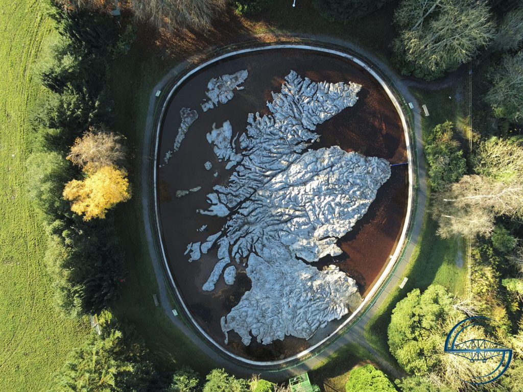
Barony Castle Hotel is also home to The Great Polish Map of Scotland, also known as Mapa Scotland. The map is a large, outdoor, concrete scale model of Scotland, measuring 50x x 40m.
The map was built over six summers between 1974 and 1979. It was mainly the work of a small group of Poles from the Jagiellonian University of Poland.
You can read all about the map, and it’s history on the MAPA Scotland website.
But back to the wedding in this post!
Working with the wedding photographer allows a real sharing of knowledge to take place.
The drone pilot can draw on the photographers knowledge of image composition and setup.
It allows the photographer to ensure that the images from the drone are consistent with the theme and feel of the day that they are trying to achieve.
The drone pilot adds the experience of positioning the drone and how shots that are not possible from the ground can be achieved.
The drone pilot also knows the capabilities of the camera on the drone and can work with the photographer to achieve fantastic results.
The Great Polish Map was a challenge for the photographer, with a lot of shadows from the trees surrounding the map. The grass areas around the map are also close to the railings running around the map.
With the drone we could position its camera over the map itself which provided many additional options for image composition.
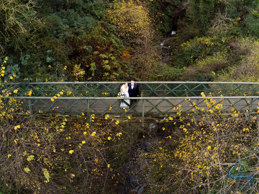
There is a bridge over a small glen between the map and the hotel. This is a great opportunity for the drones abilities. Dropping the drone down between trees and hovering over the glen to capture a photograph of the happy couple on the bridge.
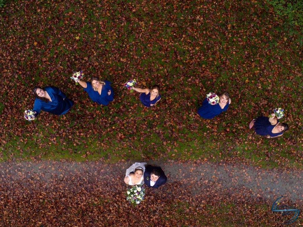
The drone can also look straight down, making great shots like this possible.
During the photography session we were also able to take some video clips of the wedding party.
After editing, we combined the wedding party clips with footage of the map and hotel. By adding in some photographs with effects and transformations we created a short video of the occasion.
Music on a video like this needs to be personalised. We prefer to take time to discover the couples musical tastes and source music that matches. Much like a film, the music is an important part but the video needs to work with the musics beat and timing. Making sure transitions between clips happen at the right time, or using a sweeping shot where it works better with the music.
The location for the wedding was an opportunity we couldn’t miss doing more with.
We saw that the weather on the wedding day was likely to be overcast. With the permission of the hotel, we performed extra flights on the day before the wedding. This allowed us to capture some shots of the area when the weather was better.
It also allowed us to perform mapping flights over the map. Yes, we mapped the map!
The data from the mapping flights was then processed to generate orthomosaics from the images. Going further we were able to take the images from the short mapping flights and generate a 3D model of the map.
All of the extra footage we didn’t use for the wedding video didn’t go to waste either. We used clips from the flights on the day before the wedding to put together a short video of the Great Polish Map.

We have shared this data, and the various outputs, with Mapa Scotland, the charity who care for the Great Polish Map of Scotland. They hope to be able to use the various images and model for promotion of the map and charity.
Drones are very versatile tools. This is just one example where we have performed the main task of the day, the wedding, and gone on to generate much more from the images and video.
Get in touch to discuss your requirements, from photography and video creation to aerial mapping and 3D model generation.