In a single word, yes!
Whether the building is your home or a commercial building, a drone roofing inspection can be a great option to help when assessing the condition of the roof.
The high-resolution camera and the ability of the drone operator to position the drone at almost any point above the roof makes the drone a very useful tool for roof surveys.
In this post, we examine how a drone is an effective tool for roof surveys on both residential and commercial properties.
Total Reading Time: 7m 30s
What is the difference between a roof inspection and a roof survey?
There is an important difference between a roof inspection and a roof survey.
A roof inspection is an external visual assessment of the condition of the roof. It will examine the state of the roof covering, gutters and pipes, and other visible areas.
A roof survey is more detailed and is performed by a professional roofing company. They will assess the roof condition for water leaks/ingress, potential failure points, internal structural issues and other items.
This article discusses roof inspections.
When would a roof inspection be needed?
Roof condition inspections are required when there is a suspected problem with the roof. They are also performed when monitoring the roofs condition as part of a routine maintenance schedule.
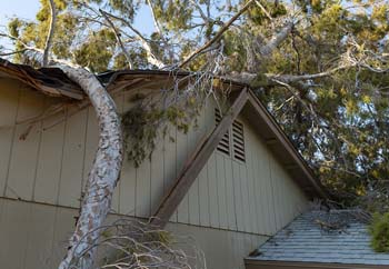
A roof may need inspected when it has been damaged by weather or when buying or selling the property.
In these cases, someone will need to be able to see the roof up close and see as much of the roof as possible to assess its condition.
How is a roof inspection usually done?
A traditional roof inspection will involve a professional roofer physically gaining access to the roof and examining different areas of the roof. This may be as simple as the roofer using a ladder, and any skylight access when the roof is easy to access.
If the roof is higher or has poor access, you may need a scissor lift/cherry picker to give the roofer a platform for examining the roof. For a roof with very poor access the roofer may need to use scaffolding.
A roof inspection takes place at height which can never be completely safe. Qualified roofing companies will put in place training and safety procedures to make the process as safe as they possibly can.
Is a drone roof inspection safe?
Safety is one of the big benefits of using a drone for a roof inspection. The drone operator will normally be on the ground. The operator will be able to position the drone using both line of sight and the live video feed from the drone camera.
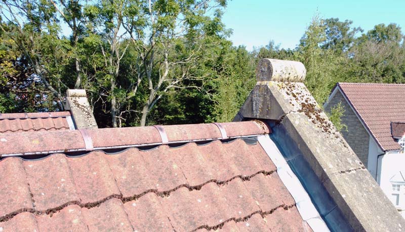
The drone never touches the roof. The high-resolution camera system means that it can take images from several metres away. This is an important point to consider if you are using a drone inspection to visualise a damaged roof that may be unstable.
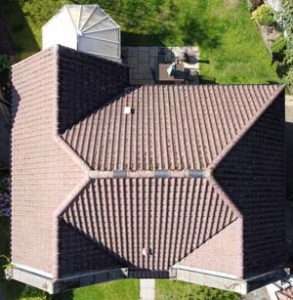
Residential property roof inspection
A drone is a great way to visualise your roof when you need to look at problem areas. It is quick and safe. The image quality allows you to visualise areas of the roof that would normally be difficult to access.
A drone can, for example, provide excellent images of chimney stacks. A few drones have cameras that can look straight up, which is ideal for seeing underneath any overhangs.
The number of images the drone operator takes will depend on your requirements. You may only need two or three images of a particular part of the roof, or you may require more images to cover the entire roof in detail.
If you are on-site with the drone operator then you can request particular images and angles. You can often see the images right away to ensure they meet your specific requirements.
Drones can also be used to take video clips of the roof. The drone could, for instance, provide a clip of a slow flight along the lines of guttering to allow you to check for blockages.
Other, often overlooked, aspects of a drone-based roof inspection is that you can ask the drone operator for images of other parts of the house. Maybe you have hard-to-reach windows which need repairs. The drone operator could take images of those at the same time to allow you to assess the state of repair.
Drones can also be equipped with thermal cameras that can provide even more information about the condition of the roof.
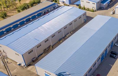
Commercial property roof inspection
All of the benefits of a residential, drone-based, roof inspection also apply to commercial buildings.
However, commercial property roof inspections differ from residential property roof inspections in a number of important ways.
Commercial inspections can form part of a regular maintenance inspection for the roof.
A drone can be used for routine imaging of the roof to help detect potential issues before they become serious. This allows the work to repair the affected area to be factored into a maintenance plan.
Commercial buildings also tend to be much larger than residential properties. This makes using a drone to gather the images even more attractive.
The drone can fly for as long as the battery has a charge. Typically a drone used for roof inspections will have a flight time of around 25 minutes per battery. A good drone services company will always arrive on-site with multiple batteries per drone and with at least one backup drone.
For larger commercial buildings, the drone can be pre-programmed with a flight plan to cover the entire roof surface. This opens the possibility of creating a single image of a large roof area. This is done by stitching together multiple images to form a single image known as an orthomosaic. This technique is commonly used for imaging large areas of farmland or construction sites.
If there are multiple commercial buildings on the same site, then the drone operator can potentially image several buildings in a single visit.
All the captured images, and video, from the drone flights, can then be examined from the comfort of the office.
Can a drone be beneficial to a roofing company?
A drone can be a great tool for a roofing company to use to obtain roof images.
They can use the images to assess problematic areas of the roof surface before sending staff to repair them. They can also the images to spot areas of the roof which need to be surveyed in more detail.
Not every roofing company will be able to own and operate its own drones.
The funding for the drone itself is one element. The staff operating the drone also need to be trained and authorised for commercial flying.
The roofing company may also need specific authorisations from the Civil Aviation Authority (CAA) to operate the drone. This represents an ongoing cost. There are also insurance requirements to consider when operating drones commercially.
Commercial drone operators are required to plan and risk assess every flight. This can be simple and quick. When more complex permissions to fly are required, or the building is close to hazards, the planning will take longer.
There are benefits to both the roofing company and the drone services company when they partner to provide services.
The roofing company can offer drone-based inspections as part of its services. This frees staff for other jobs since they’ll only need to look at the drone images in the first instance.
The drone services company will also have access to qualified roofing professionals. This allows them to provide reports on roofing images for their clients.
Can a roof inspection help progress an insurance claim?
If you are looking for help in supporting a claim to your insurer, or if you are an insurer looking for quick visualisation of damage, a drone is an ideal way to gather images.
If you need extra information to support a claim, a drone inspection can be a quick option. The images can be included with your claim to support the other details you provide. Obtaining the images will be quick and the insurer will be able to examine the high-resolution images.
For the insurance company, a drone operator can be on-site quickly. They can image the roof to your requirements, and send the images directly to you. Images can be sent from the site or immediately after post-processing.
How much does a drone roof inspection cost?
It may be a standard answer, but the cost of a drone-based roof inspection varies from company to company.
The cost could be as little as £200 for a small number of images of a residential property. For a large commercial property the cost could start at around £450. The quoted price will always reflect your specific requirements.
There are several items that affect the price.
Like any professional service, the level of certification and authorisation the drone services company holds will affect the price.
A cheaper quote could indicate that the company holds basic certification such as the A2 Certificate of Competency (A2CofC).
A higher cost quote could indicate the company holds an operational authorisation from the CAA. This would be the General Visual Line of Sight Certificate (GVC).
Note that the company may currently operate under a Permission for Commercial Operation (PfCO) from the CAA. This was the commercial certification used prior to the recent regulation changes which introduced the GVC. Companies that use the PfCO will be moving to the GVC certification.
Companies that hold a PfCO or GVC level of certification are regulated by the CAA.
Any drone company offering commercial services is required to have specific commercial drone insurance cover in place.
The location of the building to be inspected is a key pricing item since it affects both the travel costs and the pre/on-site planning of the inspection.
Planning for a drone flight will look at the location, assess the risks of the site, and determine the required permissions for the drone flight. The drone services company will normally obtain the necessary permissions. If the permissions are complex then this could increase planning time and increase the cost.
Your requirements also have an impact on costs. How many images do you need? Are the images being supplied as-is or do they need post-processing? Does you need a video of the roof? Does you need any extra reporting on the findings? These are just examples, you should always discuss your specific requirements with the drone services company.
It is normal for drone services companies to provide free quotations. You can get in touch with one, or more, and ask for a quote. This will allow you to compare services and is the simplest way to determine how much the inspection will cost.
Most drone services companies are happy to answer questions and provide free information.
Conclusion
The aim of this post is to provide enough information to help you decide if using a drone to inspect a roof is a possible option for you.
A drone is a fantastic tool for visualising places that are at height or difficult to reach. A drone can be used where the roof is damaged. It can also be used as part of a regular maintenance inspection.
By working with a drone services company you should be able to easily get images you need.
Using a drone for a roof inspection is safe, normally very quick and the cost will usually be far lower than hiring a roofing company to physically look at the roof.
When you need a more detailed roof survey the drone operator can partner with a professional roofing company to provide a complete survey service.
So, the answer to “Can a drone be used to survey a roof?” is an emphatic Yes!